GUI user guide
This guide is built around the project setup checklist in FMU Settings.
For most users, the main goal is simple: open the project and work through the checklist until the setup is complete.
Project setup checklist
On the home page, FMU Settings shows a checklist that helps you see what is missing to complete your project configuration.
The checklist tracks whether the project has:
model information and access control
masterdata
RMS project, stratigraphy, and wellbores
stratigraphy and wellbore mappings
This guide follows that same setup flow.
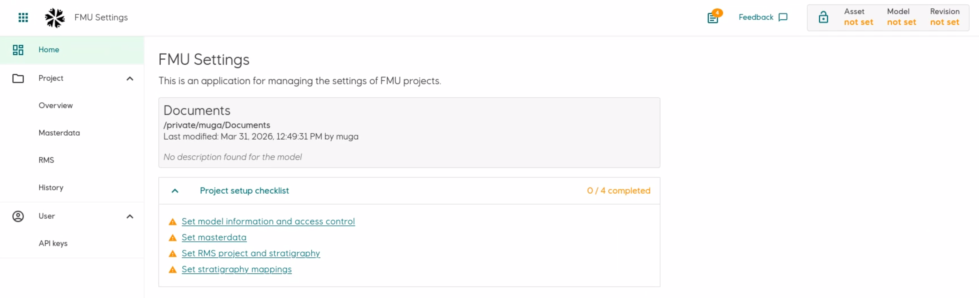
The FMU Settings home page with the project setup checklist.
Start the application
Start the GUI from the command line:
fmu settings
FMU Settings opens in your browser.
Select a project
If no project is selected, the front page shows a Select project button.
In the project selector dialog you can:
choose one of your recent projects
enter a project path manually
If the project is already initialized (has a .fmu folder), it opens directly.
If the project has not been initialized yet, FMU Settings can do that for you and then open it. See Getting started for more information about initializing a project.
Home page
The home page gives you a quick overview of the project. It shows:
the currently selected project
when it was last modified
a short model description, if one is set
a project setup checklist
Step 1: Fill in project information
The Project page is the main page for the selected project.
Here you can see:
basic project information
current lock status
model information
access control settings
You can also use Change project to open another project.
Read-only and editable mode
To avoid people overwriting each other’s work, the project can be either:
editable
read-only
If the project is read-only, try Enable editing. If someone else is already editing, FMU Settings shows who currently holds the lock.
Model
The Model section contains information about the model:
name
revision
description
Each model needs a name and revision, usually matching your project’s directory structure. For example, for the project path /project/field/resmod/ff/25.0.0/, the name would be ff and the revision 25.0.0.
Access control
The Access control section is used for exported data.
This section is used to configure access permissions for data exported from the project.
Here you choose:
the Sumo target asset
the default classification
Supported classifications are:
internalrestricted
The asset specifies the target asset in Sumo where data will be uploaded. The classification sets the default information classification for the data.
Read more about access control in the Sumo documentation.
Pick a Sumo asset from the list when possible. If you cannot find the asset there, you can type it in yourself.
Step 2: Add the SMDA subscription key
Open the API keys page from the left menu under User > API keys.
This page is where you save personal API keys used by FMU Settings.
Right now, this page is used for the SMDA subscription key. You need this key when working with masterdata in the GUI.
The page itself includes instructions for how to get the SMDA subscription key, so you can follow the steps there when setting it up.
After you save the key, it is hidden in the application.
Note
SMDA is the database containing the master data.
Step 3: Set up masterdata
The Masterdata page shows the masterdata references saved in the project, including:
field
country
coordinate system
stratigraphic column
discoveries
To update masterdata:
Make sure the project is editable.
Make sure an SMDA subscription key has been added on User > API keys.
Enable editing mode on the Masterdata page.
If FMU Settings says required data is missing, use the guidance shown on the page to log in with SSO or add the access token to the session.
When editing is enabled, you can add or update masterdata from SMDA.
If required data for editing masterdata is not present, the page tells you what is missing. In practice this means checking that:
an SMDA subscription key is present
an SSO access token is present
Step 4: Set up RMS project data
The RMS pages connect the FMU project to its RMS project. Use these pages to select the stratigraphy and wellbores to use in mappings.
Select RMS project
Open RMS > Overview. This page shows the main RMS project in the rms/model directory. FMU Settings detects the version automatically.
Use Select RMS project or Change RMS project to choose the RMS project.
Access the RMS project
FMU Settings must access the selected RMS project before it can read the stratigraphy and wellbores.
To access the RMS project:
Open RMS > Overview.
Select Access RMS project.
Wait until the page shows that the RMS project is ready for access. This can take a while.
Note
FMU Settings accesses the RMS project in read-only mode.
Select Reload RMS project to refresh the RMS data. If you want to choose a different RMS project, first select Close RMS access. When you switch FMU projects, FMU Settings closes RMS access automatically.
Set project stratigraphy
Open RMS > Stratigraphy to select the RMS horizons and zones to store in the project. This page does not create SMDA mappings.
The RMS project must be ready for access before FMU Settings can read the available stratigraphy.
To set the project stratigraphy:
Select Add or Edit.
Select horizons and zones to add or remove them. You can also use Add all or Remove all.
Select Save.
Only the stratigraphy stored in the project is available on the stratigraphy mappings page.
If the project contains horizons or zones that no longer exist in RMS, FMU Settings asks you to remove them before saving.
Set project wellbores
Open RMS > Wellbores to select the RMS wellbores to store in the project.
The RMS project must be ready for access before FMU Settings can read the available wellbores.
To set the project wellbores:
Select Add or Edit.
Use the Include checkboxes to select wellbores. You can filter the list and use the buttons to select or deselect all filtered wellbores.
Select Planned to set a wellbore as a planned wellbore.
Select Save.
Note
Planned wellbores can be mapped to simulator names, but not to SMDA names. They appear as blue rows on the wellbore mappings page.
Step 5: Map RMS stratigraphy to the stratigraphic column in SMDA
Open Mappings > Stratigraphy to map the stored RMS stratigraphy to the SMDA stratigraphic column selected in Masterdata.
The page displays the stratigraphy selected in Step 4, with the source names marked as “RMS”. Each horizon and zone has a corresponding SMDA field. The field shows (not set) until it is mapped.
This page is separate from RMS > Stratigraphy. The RMS page controls which horizons and zones are stored. The mappings page controls the SMDA name and RMS aliases for each stored element.
In SMDA, zones are stratigraphic units. Horizons define the tops and bases of those units.
Map RMS to the stratigraphic column in SMDA
Make sure that the project is editable, and then enable editing mode.
Select the Edit icon (pen symbol) for the zone or horizon to map.
Select the corresponding SMDA name from the selected stratigraphic column.
If needed, add one or more aliases for the RMS name.
Select Save.
Map zones first. After you map an adjacent zone, its top and base horizons appear at the top of the list of available SMDA options for the RMS horizon.
If an RMS zone or horizon is not defined in the SMDA stratigraphic column, select Zone doesn’t exist in SMDA or Horizon doesn’t exist in SMDA.
Step 6: Map RMS wellbores
Open Mappings > Wellbores to manage RMS, simulator, and SMDA names for the wellbores selected in Step 4.
Make sure that the project is editable, and then enable editing mode. To map SMDA names, you must also have:
a field in the project masterdata
an SMDA subscription key
an active SSO access token
Edit one wellbore
To edit one wellbore:
Select its row in the table.
Enter its Simulator name, select its SMDA name, or do both.
Select Save.
If the wellbore is not defined in SMDA, select Wellbore doesn’t exist in SMDA. This completes the SMDA mapping task for that wellbore.
Planned wellbores can only have simulator names.
Import or export simulator names
If no simulator names are saved, select Import simulator names to read them from an rms_eclipse.csv file. The default path is:
rms/input/well_modelling/well_info/rms_eclipse.csv
FMU Settings reads the RMS_WELL_NAME and ECLIPSE_WELL_NAME columns. It imports names only for RMS wellbores that are stored in the project.
When simulator names are saved, select Export simulator names to write an RMS simulator renaming table. The default path is:
rms/input/well_modelling/well_info/rms_simulator.renaming_table
You can enter another path relative to the project root for either operation. FMU Settings asks for confirmation before it overwrites an existing renaming table.
Get suggested SMDA names
Projects can contain thousands of wellbores. Mapping each RMS name to an SMDA name manually can take a long time. Suggest SMDA names compares the names and proposes likely matches for non-planned RMS wellbores that are not yet mapped.
Identical names most likely refer to the same wellbore. However, RMS and SMDA can use different prefixes for that wellbore. For example, one system can include a country prefix while the other does not. Ignoring the prefix lets FMU Settings compare the remaining parts of the names.
To generate suggestions:
Select Suggest SMDA names.
In Prefixes to ignore, keep or change the prefixes used for name comparison. Country prefixes are selected by default. You can also add other prefixes.
Select Generate suggestions.
Review each suggested RMS and SMDA pair. Select only the pairs that refer to the same wellbore.
Select Save selected SMDA names.
Prefix rules change only the comparison. FMU Settings saves the complete SMDA name. Exact name matches are selected automatically.
Warning
Suggested matches are based on name similarity. A matching name does not prove that the RMS and SMDA names refer to the same wellbore. Verify each suggestion before saving it.
To complete the project setup checklist, each non-planned RMS wellbore must have an SMDA name or the Wellbore doesn’t exist in SMDA selection.
Optional: Review earlier saved versions
The History page lets you look at earlier saved versions of project data.
You can currently browse saved versions of:
project configuration
mappings
A snapshot is a saved version of the project configuration or mappings. Choose a resource to view its snapshots, listed from newest to oldest.
For each saved version, you can:
use View details
compare it with what you have now
restore it
Use View details to see what has changed between the snapshot and the current version. If the project is editable, you can also restore from the snapshot.
When you restore an earlier version, FMU Settings first saves a backup of the current one.
You cannot restore while the project is read-only.
Set the maximum number of snapshots
Use Max snapshots to control how many snapshots FMU Settings keeps on disk for the project.
Select the maximum number of snapshots to keep.
Select Save.
If you reduce the maximum, FMU Settings shows how many old snapshots will be deleted before you confirm the change. You cannot change this setting while the project is read-only.
Summary
For a new project, a simple order is:
Open or initialize the project.
Fill in Project information.
Add the SMDA subscription key on User > API keys.
Set and verify Masterdata.
Set the RMS project.
Select the RMS stratigraphy and wellbores to store in the project.
Map the stored RMS stratigraphy to the selected SMDA stratigraphic column.
Map non-planned RMS wellbores to SMDA names. Add simulator names if the project needs them.
If you need to look back at earlier saved versions, use the History page.